Applications

Pipeline Characterization

Route, depth of cover and ground conditions along pipelines.

Overview

Operators, engineers and land owners need to know exactly where a pipeline runs, how deeply it is buried and what the ground around it is doing. We combine drone magnetics and LiDAR along the right-of-way with ground GPR, EM and resistivity at crossings and problem spots to map the line, its cover and the soil and geohazard conditions that affect its integrity.

Drone-enabled

What we map

  • Pipeline alignment, bends and depth of cover
  • Unmapped, abandoned and foreign-line crossings
  • Soil resistivity and corrosivity along the route
  • Geohazards: voids, shallow rock, wet ground and slope movement
  • Exposed or shallow sections at crossings and erosion points

What you receive

  • GIS alignment with depth-of-cover profile
  • Crossing and foreign-line inventory
  • Soil resistivity/corrosivity profile along the route
  • LiDAR terrain model and orthomosaic of the right-of-way
  • Geohazard map with recommended follow-up

Recommended methods

Geophysical result for pipeline characterization
Example output

Examples

Example scenario

Right-of-way assessment

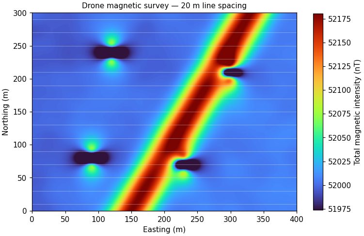
A drone flies magnetics and LiDAR over 20 km of right-of-way in two days. The magnetic data trace the steel line and two unmapped crossings, LiDAR flags erosion at a creek crossing, and GPR and EM confirm depth of cover where the drone data show the line coming shallow.

Example scenario

Corrosion and geohazard screening

Resistivity soundings and an ERT line along a pipeline segment identify low-resistivity, corrosive soils and a saturated zone above shallow rock, guiding where the operator focuses coating and cathodic-protection inspection.

Planning a pipeline characterization project?

Send a location and the question you need answered. We'll recommend a method and a budget range.

Connect with us

Let's talk about your project.

Send a location and the question you need answered. We'll recommend a method and a budget range.